
The 1852 U.S. Coast Survey is one of the first maps that details many of the topographic, physical, and cultural features of San Francisco’s “Mission de Dolores.” We can see details of the rich historical ecology that supported Yelamu Native Americans in the pre-colonial era (part of the larger Ohlone group of peoples), as well as the Spanish, Mexican, and American settlements that came later on.

The prominent hydrological features in the historical Mission lands are Mission Creek and Mission Bay. Mission Creek, incorrectly called a lake in some historical scholarship, was a tidal body of water that drained freshwater runoff from the hills and creeks in the Mission and ultimately emptied into Mission Bay. We have the presence of Mission Creek and Mission Bay to thank for the unique system of parallel curved streets that you find in San Francisco south of Market Street. The Mission Street Plank Road, seen in the map above, was built in 1852 and represented the first planked road that connected downtown San Francisco with the growing suburb of the Mission “district.” As new roads were built south of Mission Street, between downtown and the Mission and Potrero, they followed this curved pattern established originally by this Mission Street Plank Road.
 In the pre-colonial era, the Yelamu used the lands and waters of the Mission District to hunt land game, catch waterfowl, collect fish, clams and mussels, and gather nuts, berries, and seeds (Engelhardt, San Francisco or Mission Dolores, 62-63; Palou, Life and apostolic labors…, 214-217). The Yelamu also used Mission Creek as a means to travel around the Bay by water. The Yelamu inhabited two tribal villages located along the shores of Mission Bay and Mission Creek: Sitlintac, located in today’s South of Market neighborhood and Chutchui, located in today’s Mission District, probably along the waters of old Mission Creek (Milliken, Time of Little Choice, 61, 68).
The major east-west road in Mission Dolores that ends at the waters of Mission Creek was known in the late 1850s as Center Street–what would later become the Mission District’s famous 16th Street thoroughfare. The large marshy area at the bottom of the map is created by the intersection of Mission Creek with a smaller creek that drains approximately along the line of 18th Street. This “18th Street” creek collected freshwater runoff from the hills of Twin Peaks and Corona Heights, passed through the heart of the Mission lands, and ultimately drained into Mission Creek.

The 1873 Langley map of San Francisco (below) is interesting because you see the city’s “modern” street grid over some of the “vanished waters” of the Mission. The “18th Street” creek passes south of the Mission church through the Jewish Cemetery where Dolores Park is located today. North of the Mission church another creek formed from an underground spring near today’s Duboce Park and flowed along the line of today’s 14th Street. This “14th Street” creek also drained into Mission Creek near 14th and Folsom streets.

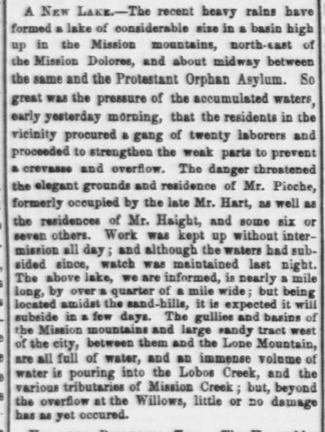
Though these creeks are largely culverted today, groundwater still flows along these historical creek beds underground, which periodically overflow and flood parts of the Mission District and SoMa neighborhoods. In January of 1862, heavy rains created a temporary lake “nearly a mile long, by over a quarter of a mile wide” along 14th Street (“City Items,” Daily Alta California, January 19, 1862). And while the modern ecology of this location is much different than it was in the 19th century, this video from the basement of the San Francisco Armory (14th & Mission) shows how groundwater still flows along this historical creek bed towards Channel Street.
The “18th Street” creek also regularly flooded 18th Street between Dolores and Mission streets creating standing bodies of water. In 1875 a boy drowned in a “lake” along 18th Street near the Jewish Cemeteries (today’s Dolores Park), a body of water that persisted for so long it earned the obviously disparaging moniker, Lake McCoppin (“The Casualty at the Mission,” Daily Alta California, June 9, 1875).” Another Christmas rainstorm in 1894 flooded the Jewish Cemetery and part of the surrounding neighborhood creating a temporary “lake.” (“The Storm Is Ended,” San Francisco Chronicle, December 24, 1894). Other contemporary articles reference the regular flooding of homes near 17th and Folsom streets during heavy rain storms, the neighborhood that is largely built on Mission Creek land fill (“Flood Prone Area of SF, Floods Again,” ABC 7 News Online, December 11, 2014).

The hill directly north of the Mission church is one of the lost landforms of the Mission District. The 1852 Coast Survey measures the hill at about 200 feet (at 20-foot contour intervals) though the 1857 and 1859 surveys show the hill at about 210 feet. A footpath on the east side of the “Market Street Hill” led through Hayes Valley and connected up with Turk Street. A footpath on the west side led through the vast sandy hills and scrub brush of the Western Addition, parts of which connected with the Presidio.
The “Market Street Hill” was graded and excavated in the 1890s, during the extension of Market Street, to provide general improvements in the neighborhood. Part of this excavated earth was used to fill up a “depression at present existing at Fourteenth and Church streets,” directly on the line of the old “14th Street” creek (“Market-Street Grades,” San Francisco Call, September 19, 1893).” Today the fortress-like U.S. Mint building on Hermann Street marks the old peak of “Market Street Hill.”
NOTES
“City of San Francisco and Its Environs.” [Map]. U.S. Coast Survey. 1852.
Daily Alta California
Engelhardt, Zephyrin. San Francisco or Mission Dolores. Chicago, Ill. : Franciscan Herald Press, 1924.
“Flood Prone Area of SF, Floods Again.” ABC7News Online, December 11, 2014.
“Map of San Francisco From the Latest Surveys…” [Map]. Britton & Rey. 1873. Accessed from the David Rumsey Map Collection.
Milliken, Randall. A Time of Little Choice: The Disintegration of Tribal Culture in the San Francisco Bay Area, 1769-1810. Menlo Park, Calif. : Ballena Press Pub., 1995.
Palou, Francisco. Francisco Palou’s life and apostolic labors of the Venerable Father Junipero Serra: founder of the Franciscan missions of California. Pasadena, Calif. : G. W. James, 1913 [1786].
San Francisco Call
San Francisco Chronicle